I took 10 days off work in the middle of Elaine’s summer holidays so we could have a tour of Scotland. Summer was the only time that seemed at all logical. Just 3 weeks before we had seen on TV all the golfers heavily wrapped in coats and jerseys for a tournament up there. If it’s that cold at the beginning of summer, it must be awfully cold the rest of the time and completely miserable in winter.
When you see the weather conditions in Scotland on the News and compare them every night to our own in St Albans, it gives you this resolute conviction not to go there, but Elaine was dead keen because that’s where the Campbells, Waughs and Maxwells of her family come from and she very much wanted to see her cousins in the Scottish Borders area. We had only just finished moving in to our new flat on the Saturday and we simply left all the mess behind and hit the road on Monday morning.

Moving in. Our new flat
“‘ull,” he said.
“And what’s the weather like up in Hull?”
“Grey. Overcust.”
“It’s lovely here in London, you know. There’s sunshine and clear skies.”
“We’ve got grey. Lots of northern grim. We don’t go in for sunshoine oop ‘ere you know.”
“I’ll look out for it when I’m driving past.”

A taste of Northern Grim
“Is that it for northern grim?” said Elaine.
“It could be for the ‘ull version of it, but there’s plenty of North to go.” There were large signs appearing with warnings about long delays ahead, but so far the A1 was clear. We stuck with it until we were almost at the A1(M), a stretch of the A1 improved to motorway standard and under motorway driving rules. There we stopped, along with thousands of other cars in two undulating rows ahead of us and a long tail beginning to grow behind us.
“Oh, nice. Anywhere to pull off?” Elaine groaned.
I looked down at the map on my knee and then up into the gentle glow of early evening sunshine on low, rolling English countryside.
“Harrogate sound ok?”
“Harrogate?”
I looked up the Lonely Planet. “19th Century spa town. Fashionable, affluent, elegant. Stately Victorian terraces.”
“Lovely. And it’s late enough for us to stay there overnight. Where do we turn off?” Harrogate was absolutely beautiful.
Beautiful domed buildings in delicately crafted stone lined many of the streets and small colourful gardens dotted the public lawns. We found a very centrally located B&B right opposite the conference centre and then wandered around the middle of town looking for somewhere to eat.
This is it, on the right – behind the baskets of hanging flowers – Betty’s Kitchen. What a treat! We actually felt out of place in our travelling clothes so we went back to the B&B and changed for dinner. It was worth it. There was a quiet elegance about Betty’s Kitchen, a piano player drifted his fingers through semi-jazz tunes and he played Waltzing Matilda for us because he had guessed we were Antipodean and probably thought Australian was a good bet.

The Royal Bath House, Harrogate

Betty’s Kitchen, Harrogate
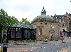
The Royal Pump House, Harrogate

Angel of the North, Gateshead

On the causeway to Holy Island
“About once a week, anyway.”
“And do you always come down to check them out?”
“He could have made it if he’d got that far because the water between the bridge and here is not as deep as the water between the bridge and the island. But they see the water in front of them and they stop on the bridge. The water is very fast, you know. He can get washed off that bridge; he’s not necessarily as safe as he thinks he is.”
“Why did he get caught?” The policeman looked me over again.
“If I knew that, I’d answer some of the riddles of the universe.” He grinned. “You see the tide times? That white board over there?”
“You mean next clear causeway time is 1730 today?”
“Yup. The times on there give you a full hour of grace. If it says be off the island by 6:00pm tonight, you’re actually reasonably safe till 7:00pm. This idiot has missed even that.”
I put my camera on full zoom and peered intently at the little red car. “The water is up to the middle of his wheels. Does it get any higher than that?”
“You see the rails on the bridge? I’ve seen them disappear. With the water that high, it would wash away a big 4×4 like mine.” He looked at the car on the bridge, “He’s lucky it’s an exceptionally low tide.”
He looked steadily at me one last time. “Yeah, I come and check them out every single time.”

Tweed rail viaduct
It’s a town that’s typical of the Borders area. It isn’t in Scotland now, but it has been many times. Berwickshire is in Scotland and Berwick is just outside its modern borders, but the Berwick football team
plays in the Scottish League. We were only able to get a brief look at the Elizabethan ramparts that surround the town but it seems they are the main reason the town stayed English after all those adventures while being Scottish.

Berwick Town Hall

Berwick stocks

Elizabethan ramparts, Berwick
They were built by Elizabeth 1st in the 1550’s and were a very effective town defensive system. In the very middle of the main street was the Town Hall. It was built and paid for by the mayor of Berwick in the late 1700’s. It’s a remarkable building, all the more so because a later mayor in the 1840s completely renovated it. The Victorians had a deep sense of civic duty.
It was a short drive out of town along the A1 and then down the narrow road to the Lindisfarne causeway, this time fully exposed all the way to the island and completely dry from having been quietly toasted in the late afternoon sun. The most striking thing about the island on first glance is the steep crag with a small castle on top so built into its fabric as to appear to have grown there out of the living rock. We parked the car, paid the toll and walked a sealed road into the village. A sign announced Lindisfarne Village, population 160. There were two pubs and two stores. This is one of the wonders of the English way of life; the tide brings people to this island in a circular kind of pattern. When there’s water over the causeway no-one can come or go, so visitors arrive here in large clumps at regularly rotating times of day according to the tide tables. The shops, however, are open 9:00am to 5:30pm. It was 6:00pm so they were closed even though the tide had just brought in 300 or so people to explore.

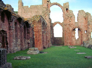
Lindisfarne Priory

St Cuthbert near Lindisfarne Priory
Lindisfarne was one of the cradles of British Christianity. This priory wrote the Lindisfarne Gospels, so beautifully decorated and embellished as to be almost magical. Some of the detail on some of the pages is so intense you need a magnifying glass to appreciate its intricacies. St Mary’s Church right on the priory doorstep was
another of those beautiful little Norman churches not altogether enhanced by repairs and modernisation carried out by the Victorians. There is a wall that has a Saxon arch – this little church has deep roots. In front of the altar is a wonderful piece of carpetmaking by the local women wherein they have reproduced a page from the Lindisfarne Gospels, with large doses of brilliant red and shining gold.
I walked through the priory ruins, and watched the golden evening sunshine washing over the little harbour at the very door of the church and walked out onto a sealed road towards Lindisfarne Castle.
When Henry V111 dissolved the monastries in the 1550’s, he took the treasures from the inside of the priory and built this castle on the crag from its stones as one of his northern defences against the Scots.
It’s now owned by the National Trust after having been a coastguard station for a while and was a private residence from the 1880’s. When I got to the castle it was closed but I had caught up with Elaine and we stood on the highest step with a small group of people who had all missed the opening time of the castle and admired the commanding view we had of a very long stretch of coast.
The lady behind me had said exactly what I was thinking. “And I wonder how old they are?” I asked. As we walked back down the road I walked past a Coast Ranger in a bright yellow safety jacket. “Do you know what the obelisks are all about?” I asked him.
“When did they go up?” I asked
“In the 1840’s, I think. They have been there quite a while.”
“What a beautiful afternoon,” I said. “And it’s nice and warm. I was expecting cold, rain and plenty of clouds.” I told him my story about Northern Grim in my rather poor best Northern accent. He grinned knowingly.
“We say up here,” he said, “that the Geordie celebrates only two days in the year: one’s his birthday and the other’s summer.”

Lindisfarne boat-shed
Wed 21st We rang Edith Scott, Elaine’s grandmother’s cousin. “She is Grandma Maxwell’s first cousin,” Elaine said authoritatively, “and she lives in East Fishwick.” Edith was delighted to hear from us when we rang her from the car. We thought we’d be there about 10:30am. “I shall be able to take you to some of the places your family knew well in the Borders,” she said. Then she told us how to get to her place – next road on your right after the maize maze. “The maze maze?” I asked Elaine.
“No, the maize maze. Someone out there has cut a maze into his maize crop. People are going there and paying a couple of quid each to walk through it. He’ll probably make more money out of the maze than out of the maize.” She grinned broadly and we drove through a beautiful sunny morning towards the Scottish Borders.

Highland cattle and heather-covered hills
Of course we took several wrong turnings getting to Edith’s and when we got to the sign for the Maize Maze, we turned down the next road and ended up alongside the Tweed, with cars in front and cars behind, queueing up for the maze. It didn’t look possible to get to Edith’s from there so we carefully crawled back up the narrow dirt road, dodging the 4×4’s that now seem to be obligatory transport if you have a rural turn of mind.
Edith was welcoming and absolutely delighted to see us. We had been warned that she might be frail or easily tired and to be careful not to overtax her. She made us a cup of tea and wheeled it in on a little trolley. She was recently out of hospital from having her knee operated on so she moved slowly and with great care. She sat with Elaine for an hour or more while she told family stories.

Edith Scott and Elaine
I looked out the kitchen window. “Is that huge hay stack part of it?”
“It’s not hay,” she said. “It’s straw. It’s used for nesting and horse beds and cow barns during the winter. And yes, that field was part of our farm.”
“Do you mean oat straw or barley?”
“Oat straw.”
“What do they do with the oats?”
There was a pause. “Rolled oats. Porridge, Dear.”
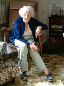
Edith Scott in her living room

Strathmore

Front door with curling stones